Photo: Paul Sorowka / Own / Society / Own Work
The Search for Touchadam Castle, Part 4: A Different Story
·
Paul Sorowka
After lockdown — and after a chance LiDAR plot in a 2024 talk — we revisited the cobbled area. What we’d assumed was an eighteenth-century midden may be hiding something a great deal older.
This is part 4 of a four-part series by Paul Sorowka on the Society’s search for the lost castle of Touchadam in Murray’s Wood, Cambusbarron. Part 1 (2018) · Part 2 (2019) · Part 3 (Lockdown research) · Part 4 (Reinterpretation)The Covid lockdown also gave us plenty of time to review what we’d actually dug. I don’t think we’ve found the remains of Touchadam Castle — but I’m no longer sure that what we unearthed is the base of an eighteenth-century midden either. The pottery had been deposited over the ‘cobbled area’ and between the large boulders, mixed in with stones and soil, presumably to make the ground level. That’s an odd thing to do if the cobbles themselves were the surface you wanted to use.
A LiDAR Lecture and a Lost Building
The site was in the corner of Murray’s Wood, which is shown on Pont’s map of c.1600, so we had assumed it was a remnant of ancient woodland and unlikely to conceal any structures older than the eighteenth or nineteenth century. We were probably wrong. In February 2024, one of our guest speakers, Dr Dave Cowley (Deputy Head of Archaeological Survey and Recording at Historic Environment Scotland) talked about developments in his speciality and, by way of introduction, showed us a LiDAR plot of a building he’d located in Murray’s Wood: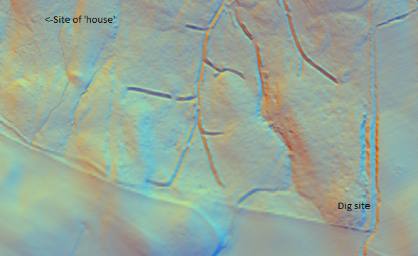
Photo: Dr Dave Cowley / Historic Environment Scotland / Other / Used with Permission
LiDAR plot of Murray’s Wood. The sinuous lines are drainage ditches; the rectangular bump near the top left is the previously unrecorded house. Courtesy of Dr Dave Cowley, Historic Environment Scotland.We investigated, and found the remains of a simple rectangular foundation — visible as no more than a slight bump in the ground — proving that early buildings could be present in an ancient wood.
Looking Again at the Cobbled Area
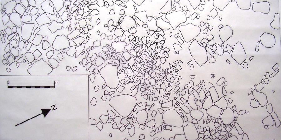
We looked again at the ‘cobbled area’ (see Part 2). The large stones and boulders that enclosed it reminded us of the Roundhouse we explored in 2008. It was possible that the cobbles were a much older surface, and that the area had simply been levelled later with soil and rubbish, by people who didn’t even know they were there. No one would bother making a cobbled surface that they intended to bury immediately. The buildings labelled ‘Castlehill’ on Roy’s map don’t appear on later maps, although another farm of the same name was located further to the west-south-west on the 1880s OS map. It is at least possible that the remains of the original ‘Castlehill’ were removed and dumped in the corner of the woodland. The LiDAR survey shows no trace of any settlement having survived (or been removed) at the location indicated by Roy — so Roy’s map may even have been wrong at this point.Drawing What We Found
We didn’t have the time or the resources to draw a conventional plan of what we’d uncovered. Instead, we set out a 1m × 1m grid with 10cm divisions and photographed the area one square metre at a time. (A 2m strip at the northern end of the trench had fewer stones and was skipped.) This was before drone aerial photography was easy, so the photos had variable amounts of overlap — sometimes none. It took quite a while to produce a reasonably accurate plan of the stones from them. But I think the result was worth it: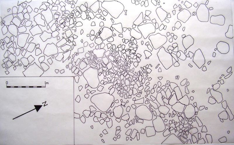
Photo: Paul Sorowka / Own / Society / Own Work
Drawing of the cobbled area after excavation, compiled from photographs taken on a 1m × 1m grid.Looking at the drawing, the largest stones don’t seem to be placed randomly. With the eye of faith (sometimes used in archaeology), I think they enclose the cobbled area, and that together they could be all that’s left of a building much older than we first thought.
The Site Today
I revisited the site this week (week beginning 6 April 2026) and it is unrecognisable. The excavated areas of 2018 and 2019 are now covered in grass; the rest is overgrown with gorse and broom. So, for anyone who would like to have a look, here’s a location plan of the trenches: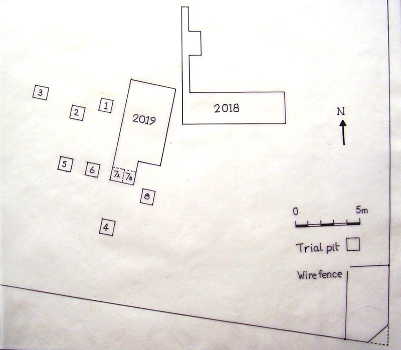
Photo: Paul Sorowka / Own / Society / Own Work
Location plan of the trenches in the south-east corner of Murray’s Wood. The 2018 trench is to the right; the 2019 trench and trial pits to the left.The site is in the south-east corner of Murray’s Wood. The fence on the east is electrified and the one on the south is topped with barbed wire — both are on the edges of the wood, so please take care if you go to look.