Photo: National Library of Scotland / Other / Public Domain
The Search for Touchadam Castle, Part 3: Lockdown Detective Work
·
Paul Sorowka
Covid stopped us digging in 2020, so we spent the time in the archives instead. Pont, Blaeu, Roy, Grassom, Fleming and a long-dead Society Secretary tell a more complicated story than the one we’d been chasing.
This is part 3 of a four-part series by Paul Sorowka on the Society’s search for the lost castle of Touchadam in Murray’s Wood, Cambusbarron. Part 1 (2018) · Part 2 (2019) · Part 3 (Lockdown research) · Part 4 (Reinterpretation)Covid stopped us digging in 2020, so we spent the time doing some research instead. The first thing we did was go back to the original sources for the location of Touchadam Castle.
Two Versions of the Same Story
We already had P.T. Paterson’s description from Bygone Days in Cambusbarron (1980): ‘All that remains of it are a few very old stones covered in grass and moss, but still decipherable as forming the foundation of walls, in Murray’s Wood between Gartur and Murrayshall.’ That information seems to have been the basis for the location shown on the 2010 leaflet. However, thirty years later, in A Cambusbarron Tapestry (2011), Paterson wrote something rather different:“Touchadam Castle is probably too grandiose a term for what is allegedly the first Murray house in this area in Murray’s Wood, to the south-east of Gartur House, not far into the wooded area at the entrance to Three Fields Path. In the 19th Century its remains, according to Fleming, comprised an oblong building running east and west, 42 feet by 18 feet, with two square buildings, 15 feet by 15 feet, probably towers, at each angle, and something like a doorway in the middle of the north side. Though just visible in the early 1980s the remains are now, through the growth of trees, difficult to conjecture — yet the name for the rising ground of its site, Castlehill, is persuasive.”The extra detail came as a surprise. It cast doubt on the identification of the surviving walls as part of a castle, and it placed the site in a slightly different spot — still in Murray’s Wood, still ‘not far into the wooded area at the entrance to Three Fields Path’, but no longer ‘between Gartur and Murrayshall’. Now it was ‘to the south-east of Gartur House’.
Following the Trail to Fleming
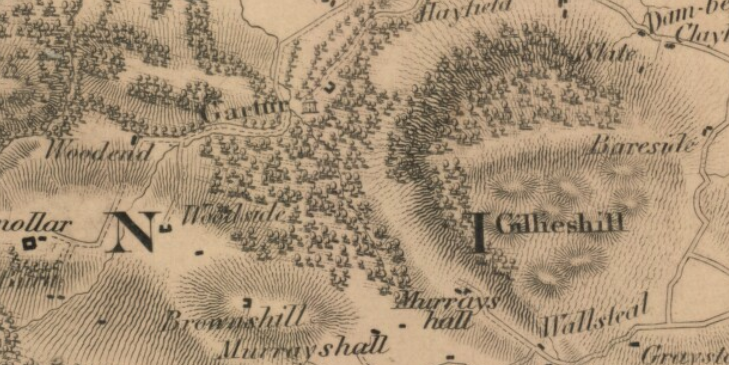
The reference to ‘Fleming’ took us to Ancient Castles and Mansions of Stirling Nobility, written and illustrated by J.S. Fleming and published in 1902. He says:“This mansion, no doubt, superseded the original family residence of the Murrays at Murrayswood or Touchadam, the foundations of which are still pointed out in the ‘Haining Shaw’, a level, wooded, plain some 300 or 400 yards on the south and at the foot of Gillieshill crag, and at the back of Gartur mansion. … These foundations, unenclosed, nowhere exceed 2 feet above the ground, are partially concealed by the growth of the turf, and all lie within an area of 90 feet by 60 feet, and walls 3 feet 4 inches thick can be traced, with two square buildings 15 feet by 15 feet, probably towers, at each angle, and something like a doorway in the middle of the north side. The ruins are mainly conjectural, have no natural defensive position, and no outworks; and it is not easy to accept the tradition that they form the remains of a residence of so great a family in the troublous times of the fifteenth century.”That last sentence is important. Fleming refers to the identification as ‘traditional’: he is not responsible for it, and seems to believe the Murrays’ former home was actually at Murrayswood (also known as Touchadam). The thickness of the walls, the position of the supposed door, the lack of any perimeter wall and the symmetrically placed corner towers must all have raised doubts in his mind. The traditional identification was not his considered opinion.
The Maps of Murray's Wood
A tower house to the north of Murrayswood appears on Pont’s map of c.1600, and seems to be given the name of the wood on the ‘fair copy’ produced by Blaeu in 1654.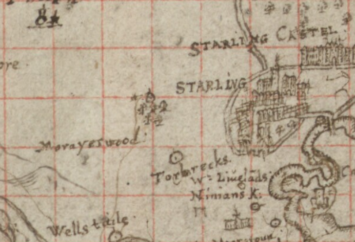
Photo: National Library of Scotland / Other / Public Domain
Pont, c.1600. Murray’s Wood (here ‘Morayswood’) is shown with a building to the north. Reproduced from the National Library of Scotland.
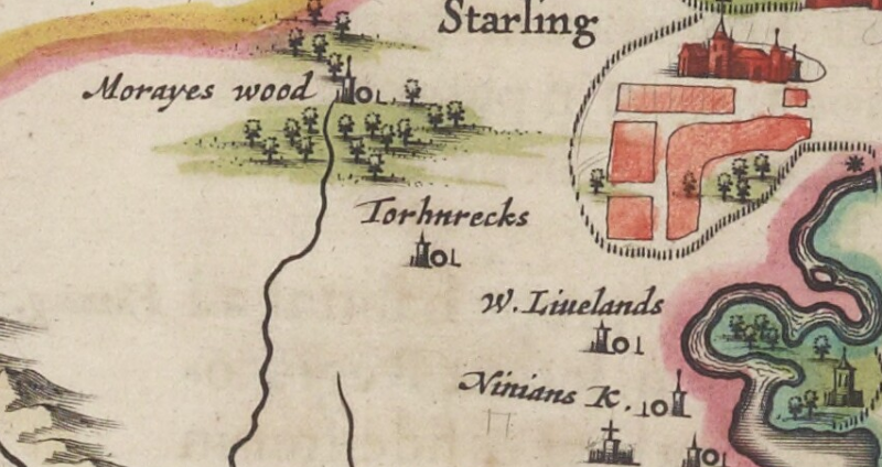
Photo: National Library of Scotland / Other / Public Domain
Blaeu, 1654, copying Pont. Murray’s Wood, Torbrex, Wester Livilands and St Ninian’s Kirk all appear. Reproduced from the National Library of Scotland.Pont’s map is a unique manuscript record; Blaeu’s is a printed version that was widely available. Blaeu’s circulation may be why Fleming believed the Murrays’ ‘original family residence’ was at ‘Murrayswood or Touchadam’. Roy’s map of c.1750, however, calls the building at the same location Woodend:
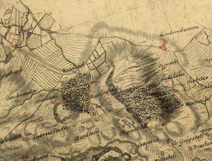
Photo: National Library of Scotland / Other / Public Domain
Roy, c.1750. The house Blaeu calls ‘Murrayswood’ has become ‘Woodend’; Murray’s Wood is un-named, left of centre, and ‘Hanging Shaw’ appears for the first — and only — time. Reproduced from the National Library of Scotland.It seems, then, that the foundations we were looking for were in the ‘Haining Shaw’ — ‘a level, wooded, plain some 300 or 400 yards on the south and at the foot of Gillieshill crag, and at the back of Gartur mansion’. The ‘Haining Shaw’ only ever appears on Roy’s map, where it’s spelled Hanging Shaw — a Scots name meaning an enclosed woodland. The only enclosed woodland nearby is Murray’s Wood. If ‘Hanging Shaw’ refers to the buildings shown below the crags, then the name may be derived from that woodland: the buildings have fields to north and south.
Grassom, Campbell and Murrayshall
Another reference to the castle’s site came from the Society’s own Transactions for 1925–26, where the then Secretary, J.W. Campbell, narrated ‘The Story of Murrayshall’ — a house built in 1673 for the young Laird of Touchadam. He and his family lived there for twenty-five years before moving in 1698 to a large new mansion at Polmaise, near the Forth. Murrayshall appears on Adair’s map of c.1685 (too imprecise to bother with) and, much better, on Grassom’s map of 1817: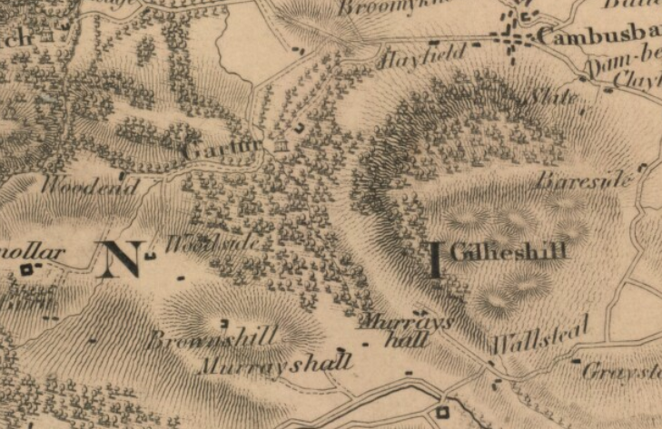
Photo: National Library of Scotland / Other / Public Domain
Grassom, 1817. A more extensive wood reaches almost to Murrayshall; Gartur is named south-west of another building, presumably the stables. Reproduced from the National Library of Scotland.The map shows the newly built mansion of Gartur — a Category B-listed and formerly derelict structure on the ‘Buildings at Risk’ register, but now restored and converted to apartments. Prior to restoration, AOC Archaeology carried out a standing-building survey (March 2019), on which the following is based:
“Gartur House started out as an 18th century Laird’s House. It originally consisted of a three-bay two-storey house with an attic before major renovations were undertaken in the early 19th century, making a large Classical-style addition with a new main entrance to the north-west of the Laird’s House. The original main entrance to the Laird’s House, to the south-east, was converted to a window. At the same time, a stables complex was built to the north-east of the house, with stable blocks to either side of a large arched entrance leading into a courtyard, around which there were cart sheds and additional stabling.”Grassom’s map matches the description closely, showing both the mansion and the stable block. The standing-building report, however, doesn’t mention any structure older than the Laird’s House — which suggests that the earlier sixteenth-century building shown on Pont’s map, probably standing nearby, had provided stone for the later ones. Its foundations may still exist. Murrayshall is shown to the south-south-east, and the name appears again to the west of the house at what is today (and was probably then) the home farm. Murrayshall house was tenanted from 1698 until 1829, when its contents were sold. It continued in use as a farmhouse until J.W. Campbell’s father ‘took a lease of it in the year 1866, and, finding the place in a ruinous condition, was sorrowfully obliged to take down the greater part of the old mansion… Except for the basement, nothing remains of the ancient structure’.
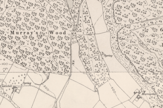
Photo: Reproduced from Ordnance Survey / Other / Public Domain
Ordnance Survey six-inch, 1888–1913. Murrayshall is shown, and one ‘field’s breadth’ to the north-north-west, the supposed site of Touchadam Castle.One might think Campbell was writing from personal experience when he notes (p.9) that ‘the Murrays of Touchadam had … their residence on the slope of the hill below the crags of the Gillies Hill, north-west of the Murrayshall farm steading’, and (p.13) that ‘Murrayshall was distant only a field’s breadth from the old Castle of Touchadam, the foundations of which may still be traced amongst the undergrowth of the Hangin’ Shaw Park’. More likely, though, Campbell was repeating a local tradition. He might not have been so confident if he had consulted Fleming — an author thoroughly familiar with the castles and mansions of the area. The area below the crags has been visited several times to search for the remains last seen there in 1968, but so far nothing has been found except for the line of an old field boundary. If anyone can point us to the location of the walls that existed in 1968, we would love to hear from you. Please get in touch. Continued in Part 4: A Different Story.