Photo: Euan Nelson / Wikimedia Commons / CC BY-SA 2.0 — Source
The Romans in Stirling: Forts, Roads and the Gaps in Our Knowledge
From Agricola's legions to the Antonine Wall, the Stirling area was a strategic corridor for Rome's conquest of Scotland. Yet remarkable gaps remain in our understanding of how they crossed the Forth.
Introduction
The Stirling area sits at a natural pinch point in the geography of Scotland. To the west lie the Highlands; to the east, the broadening floodplain of the River Forth. For any army moving north — whether Roman, medieval or modern — the Forth Valley narrows to a corridor that must be crossed. It is no accident that the Romans built forts, roads and an entire frontier wall across this landscape.
Yet despite nearly 150 years of archaeological investigation, our understanding of the Roman presence in the Stirling area remains surprisingly incomplete. Major forts have been built over by modern towns. The exact route of the main Roman road through the Forth Valley was unknown until 2023. And the strategic question of how the legions crossed the Forth — and where — is still debated.
This article surveys what we know about the Romans in the Stirling area, the transport links that connected their garrisons, and the significant gaps that remain in the archaeological record.
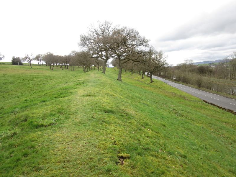
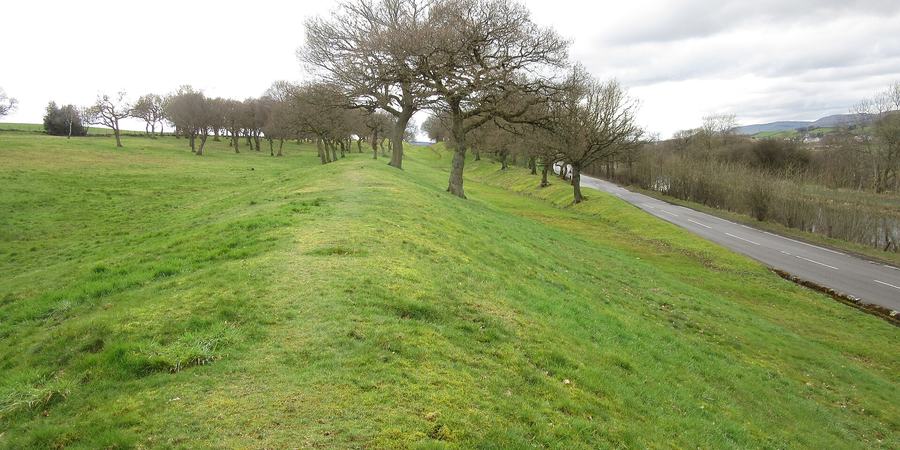
Photo: Euan Nelson / Wikimedia Commons / CC BY-SA 2.0 — Source
The Antonine Wall at Seabegs Wood, near Bonnybridge. View on Wikimedia Commons · Photo: Euan Nelson / CC BY-SA 2.0
Why Stirling Mattered to Rome
The Romans first arrived in the Stirling area around AD 79–83, during the campaigns of the governor Gnaeus Julius Agricola. His objective was the conquest of Caledonia, and the route north ran directly through the Forth Valley.
The strategic importance of the area was threefold:
- The Forth crossing — the River Forth was tidal and boggy for miles in both directions, making crossing points extremely limited and militarily critical
- The Forth–Clyde isthmus — the narrowest point between Scotland’s east and west coasts, later chosen as the line of the Antonine Wall
- The route into the Highlands — the road north from Stirling, through Doune and Dunblane to Ardoch and the Gask Ridge, was the principal supply line for Rome’s northern garrisons
The native peoples of this region were the Maeatae, whose name survives in Dumyat (Gaelic Dun Mhead, “hill of the Maeatae”), the prominent hill in the Ochils overlooking Stirling. The Roman historian Cassius Dio recorded that the Maeatae lived “close to the wall which cuts the island in half” — a reference to the Antonine Wall.
The Antonine Wall: Rome's Northern Frontier
The most visible Roman legacy in the Stirling area is the Antonine Wall, a UNESCO World Heritage Site running 63 kilometres from Old Kilpatrick on the Firth of Clyde to Carriden near Bo’ness on the Firth of Forth. Built around AD 142 on the orders of Emperor Antoninus Pius, it consisted of a turf rampart on stone foundations (approximately 3 metres high and 5 metres wide) fronted by a wide, deep ditch.
The Wall was garrisoned by 7,000 soldiers stationed at 17 forts, with up to 41 smaller fortlets between them. Three legions — the II Augusta, VI Victrix and XX Valeria Victrix — built it, commemorating their work with elaborate carved distance slabs. Nineteen of these slabs survive; eighteen are on display at the Hunterian Museum in Glasgow.
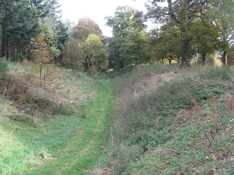
Photo: M J Richardson / Wikimedia Commons / CC BY-SA 2.0 — Source
The rampart and ditch of the Antonine Wall near Rough Castle. View on Wikimedia Commons · Photo: M J Richardson / CC BY-SA 2.0
The Wall was abandoned remarkably quickly — possibly within just eight years of completion — and the garrison withdrew south to Hadrian’s Wall. The reasons remain debated: military overstretch, political calculation, or pressure from the northern tribes.
Key Wall Sites Near Stirling
Watling Lodge (Canmore 46783): The best-preserved section of the Antonine Wall ditch, surviving to almost its original dimensions of 12 metres wide and 4.5 metres deep. This was the only point where the ditch was pierced by a road, controlled by a guardhouse tower with double gates.
Rough Castle (Canmore 46803): One of the best-preserved Wall forts, near Bonnybridge, garrisoned by the Sixth Cohort of Nervians (infantry from north-east France). Famous for its lilia — at least ten rows of concealed pits (roughly 1 metre square and half a metre deep) with sharpened wooden stakes at the bottom, the Roman equivalent of barbed wire. Julius Caesar used the identical system at the siege of Alesia in 52 BC.
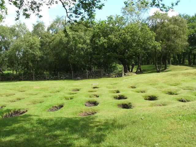
Photo: Lairich Rig / Wikimedia Commons / CC BY-SA 2.0 — Source
The lilia defensive pits at Rough Castle on the Antonine Wall. View on Wikimedia Commons · Photo: Lairich Rig / CC BY-SA 2.0
Mumrills (Canmore 47870): The largest fort on the entire Antonine Wall, covering 6.5 acres. A cavalry base garrisoned first by the Ala I Tungorum and later the Cohors II Thracum. Excavated 1923–28 and 1958–60. No visible remains survive above ground today — Polmont has been built over the site.
The Forts: Camelon, Doune and Ardoch
Camelon: The Hidden Giant
The most significant Roman installation in the Stirling area lies not in Stirling itself, but two miles north of Falkirk at Camelon (Canmore 46920). Two adjacent forts — a Flavian-era South Camp (c. AD 80) and a later Antonine North Camp (c. AD 142) — together formed the southern anchor of the road system running north to the River Tay.
The Twentieth Legion Valeria Victrix garrisoned the site (confirmed by building inscription RIB 2210). The annexe contained a bath-house and possible mansio (official guesthouse). Excavations have recovered an extraordinary range of finds: 143 coins spanning Republican denarii to the reign of Licinius I (AD 313), enamelled fibulae, bronze belt buckles, an inscribed votive altar (now in Falkirk Museum), iron-smelting furnaces and smithing hearths, face-mask jar sherds, spears, arrowheads, brooches and quernstones.
The most remarkable discovery came during a 2011 excavation ahead of a Tesco supermarket: 120 leather hobnailed shoes were found in a single ditch — the largest cache of Roman shoes ever found in Scotland. Other finds from the same dig included a Roman axe, spearhead, brooches and imported Samian ware from Gaul.
Yet Camelon’s tragedy is its near-total destruction. Railways, foundries and housing have obliterated the surface remains. The 2011 excavation covered only about 5% of the fort site; the remainder lies preserved beneath a car park, awaiting future investigation.
Doune: Guarding the Teith
Twelve miles north-west of Stirling, the Doune Roman fort (Canmore 24767) guards the crossing of the River Teith near its confluence with the Ardoch Burn. Covering 2.25 hectares, the fort was established during the Flavian period (c. AD 79–87).
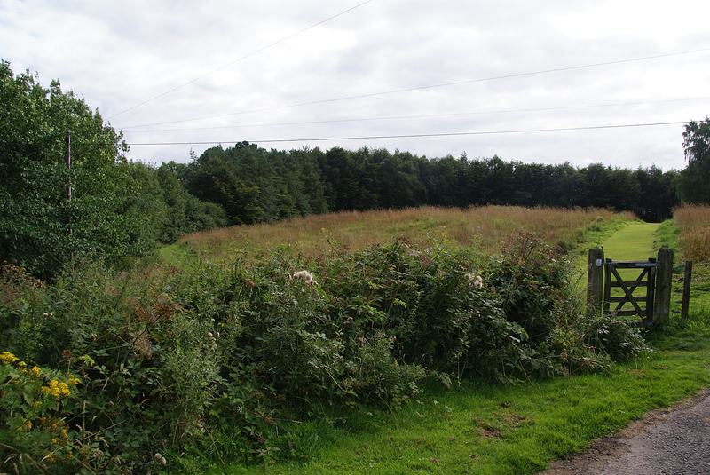
Photo: Bill Boaden / Wikimedia Commons / CC BY-SA 2.0 — Source
The site of the Roman fort at Doune. View on Wikimedia Commons · Photo: Bill Boaden / CC BY-SA 2.0
Excavations by Headland Archaeology in 2010 uncovered Samian ware and amphorae fragments, an iron-smelting shaft furnace (a first for Roman Scotland), five bread ovens built into the rampart, a gravel intervallum way (internal road) and foundations of a building interpreted as the fort’s hospital.
A cropmark annexe extends from the west angle towards the River Teith, and the discovery of marching camps at Craigarnhall on the opposite bank raised an intriguing possibility: that the Roman route into Caledonia may have bypassed Stirling altogether and crossed the Teith higher up. This remains an open question.
Ardoch: The Best-Preserved Fort in Britain
Seven miles south of Crieff, Ardoch Roman Fort (Canmore 25227) is one of the most complete Roman military earthworks in the entire Empire. The site includes a fort, at least six overlapping marching camps and a signal tower. Its multi-vallate defences — five concentric ditches on the north and east sides — are visible to this day.
Photo: Rosser1954 / Wikimedia Commons / CC BY 4.0 — Source
Ardoch Roman Fort, near Braco, Perth and Kinross — one of the best-preserved Roman forts in Britain. View on Wikimedia Commons · Photo: Rosser1954 / CC BY 4.0
First built during Agricola’s campaigns and reoccupied during the Antonine period, Ardoch was excavated by the Society of Antiquaries of Scotland in 1896–97. A tombstone found at the site (now in the Hunterian Museum) commemorates Ammonius, son of Damio, a centurion of the First Cohort of Spaniards who served for 27 years — a poignant reminder that men from across the Empire garrisoned these remote northern outposts.
Ardoch sits at the southern end of the Gask Ridge frontier — a chain of 16 watchtowers and fortlets running 37 kilometres northward to the River Tay. Dating to around AD 70–80, the Gask Ridge is the earliest known Roman land frontier system in the world, predating Hadrian’s Wall by 40 years and the Antonine Wall by 60.
Transport Links: Roads, Crossings and Supply Lines
The Roman military machine depended on efficient transport. Roads connected forts, enabled rapid troop movement and facilitated the supply of grain, equipment and building materials. In the Stirling area, three major transport systems intersected.
The Camelon–Tay Trunk Road
The principal north–south route ran from Camelon (where it connected to the Antonine Wall at Watling Lodge) northward through the Forth Valley, past Doune and Dunblane, to Ardoch, and onward along the Gask Ridge to Strageath and Bertha on the River Tay.
The road was described by early antiquarians as a “well-engineered highway”, and significant stretches remain in use today beneath modern road surfaces. Fort spacing along the route followed standard Roman practice: approximately one day’s march (15–20 miles) between garrisons, with the Glenbank fortlet (Canmore 24788) positioned between Doune and Ardoch.
Yet there was a critical gap. The Scottish Archaeological Research Framework (ScARF) explicitly identifies “a break in the Forth valley at Stirling” in the known road network. The road is documented at Camelon to the south and at Doune to the north, but the exact route through the Stirling gap — and the nature of the Forth crossing — was unknown until very recently.
The Drip Ford: A 2,000-Year-Old Discovery
In 2023, Dr Murray Cook (Stirling Council Archaeologist) made a breakthrough: the discovery of a cobbled Roman road in the garden of the Old Inn Cottage, a 17th-century drovers’ inn near Stirling. The road connected to the Drip Ford across the River Forth, next to the 18th-century Old Drip Bridge.
Cook described it as potentially “the most important road in Scottish history.” The Drip Ford was used continuously from the Roman period to the 18th century: by the Romans, the Picts, Kenneth MacAlpin, Macbeth, William the Conqueror, Robert the Bruce and Oliver Cromwell. Documentary sources mention the ford from 1304 to 1715.
This discovery partially fills the “Stirling gap” in the Roman road network, but much work remains. The full extent of the road, its relationship to the Camelon–Tay trunk road, and whether there were other crossing points in the area are all open questions.
The Stirling Crossing Debate
The discovery of marching camps at Craigarnhall on the south bank of the River Teith, opposite Doune, raised an alternative hypothesis: that the Roman route into Caledonia may not have used the Drip Ford at all, but instead bypassed Stirling and sought a crossing of the Teith higher upstream. This would imply a route west of Stirling, through terrain that has received comparatively little archaeological attention.
Dr Cook’s research into the Forth Valley’s river crossings and native settlement patterns has challenged previous assumptions, suggesting that earlier reviews “have overestimated the impact of the Roman invasion and subsequent trade” on native settlements. The relationship between the Roman road network and pre-existing native trackways remains poorly understood.
The Military Way
A secondary road — the Military Way — ran along the south side of the Antonine Wall, linking all 17 forts along the frontier. This enabled rapid lateral movement of troops and supplies. Combined with the north–south trunk road through Camelon, it created a T-shaped transport network with the Stirling area at its junction.
Naval Supply Routes
The Romans also supplied their Scottish garrisons by sea. Cramond, on the Firth of Forth near Edinburgh, served as a supply port, significantly enlarged under Emperor Septimius Severus (AD 208) to become the main logistics base. Supplies were shipped from South Shields on the Tyne to Cramond, and from there to Carpow at the confluence of the Tay and Earn, where a riverside quay for unloading seaborne cargo has been excavated.
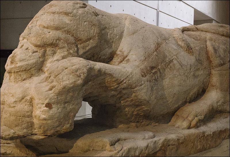
Photo: dun_deagh / Wikimedia Commons / CC BY-SA 2.0 — Source
The Cramond Lioness, a Roman sculpture found at the Cramond fort and supply base. National Museum of Scotland. View on Wikimedia Commons · Photo: dun_deagh / CC BY-SA 2.0
.jpg)
Severus deliberately chose not to live off the land but to supply his troops entirely by sea from the south — a logistical operation involving over 50,000 men. The naval supply chain bypassed the Stirling corridor entirely, which may explain why the Severan campaigns left comparatively little mark on the Forth Valley landscape.
King's Park Fort: Native Stirling in the Roman Age
In December 2017, during path works within Stirling Castle grounds, Dr Murray Cook discovered a previously unrecorded late Iron Age defended hillfort on the highest point of King’s Park. Excavation has revealed Mesolithic residual material, Samian ware (high-quality Roman imported pottery — possibly a diplomatic gift or trade item) and Roman mortaria (mixing bowls).
The fort appears to have been burned down. Cook interprets it as part of a wider pattern of native enclosures built at key locations to exploit Roman trade during the period of Roman occupation. In 2025, a previously unknown Roman Iron Age burial mound was discovered nearby, and the 2026 excavation season aims to expose a road and search for a gate, as well as excavate two burial mounds at the newly identified burial site.
King’s Park Fort is significant because it demonstrates that Stirling was not an empty landscape through which the Romans passed. Native peoples occupied this strategically critical high ground and interacted with the Roman military presence — through trade, coercion or both.
Other Roman Sites in the Area
- Malling Fort and Camps (Canmore 24038) — A Roman fort and two marching camps west of the Lake of Menteith, revealed from the air in 1968. Stracathro-type camp entrances suggest an Agricolan date (c. AD 82–83)
- Dunblane Camps — Two overlapping marching camps discovered from the air in 1950, the larger covering approximately 13 hectares
- Glenbank Fortlet (Canmore 24788) — The southernmost installation on the Gask Ridge, positioned beside the Roman road linking Ardoch and Doune. Discovered from the air by G.S. Maxwell in 1983
The Distance Slabs: Recording the Legions’ Work
Among the most remarkable Roman artefacts from Scotland are the distance slabs set up along the Antonine Wall. These elaborately carved stone tablets recorded which legion built each section of the Wall and the distance completed. They are unique to the Antonine Wall — nothing comparable has been found on Hadrian’s Wall or any other Roman frontier.
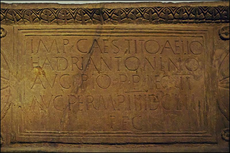
Photo: dun_deagh / Wikimedia Commons / CC BY-SA 2.0 — Source
The Bridgeness Slab, the finest Roman distance slab found in Scotland. National Museum of Scotland. View on Wikimedia Commons · Photo: dun_deagh / CC BY-SA 2.0
.jpg)
The Bridgeness Slab, found near Bo’ness in 1868, is the finest example. Its inscription records the Second Legion Augusta building 4,652 paces of the Wall, dedicated to Emperor Antoninus Pius. Flanking panels depict a victorious Roman cavalryman trampling barbarian warriors and a victory sacrifice — a vivid statement of imperial power on the very edge of the known world.
The Gaps in Our Knowledge
Despite the richness of the evidence, significant gaps remain. These are not merely academic puzzles — they shape our understanding of how Rome operated at the furthest limits of its power.
The Forth Valley Road Gap
The ScARF Roman Scotland Panel Report identifies the break in the Forth valley at Stirling as a major gap in the road network. The 2023 Drip Ford road discovery is a crucial piece of evidence, but the full route from Camelon to Doune has not been traced. Was there a single road or multiple alternatives? Did the route change between the Flavian and Antonine periods? These questions remain open.
The Crossing Question
Where exactly did the Romans cross the Forth? The Drip Ford is one candidate; the Craigarnhall camps suggest another route further west. There may have been multiple crossing points used at different periods. A systematic survey of the Forth floodplain between Stirling and Doune could resolve this, but the boggy terrain makes conventional archaeology difficult.
Camelon's Unexcavated Potential
Only about 5% of the Camelon fort complex has been excavated. The 2011 Tesco development preserved the remainder beneath a car park, but the site contains the potential to transform our understanding of Roman logistics, industry and daily life in the Forth Valley.
Fort Distribution and Strategy
The ScARF report notes “obvious gaps in the fort distribution pattern” across Roman Scotland. There has been “no systematic study of the location of forts in terms of their relationship with roads/rivers, orientation, tactical considerations” or indigenous settlement patterns. Why were forts placed where they were? How did the Romans perceive the landscape and its threats?
The Flavian Forth–Clyde Isthmus
Limited evidence supports Flavian (pre-Antonine) occupation of the Forth–Clyde corridor. Only Camelon and the Mollins fortlet provide solid structural evidence for this period. Some Antonine Wall sites have yielded Flavian finds, but the evidence is insufficient to confirm sustained first-century occupation of the isthmus. Was the Antonine Wall built on an already-defended line, or was it entirely new?
Roads That Vanished
The ScARF report suggests that some early Roman roads in Scotland were “light trackways” that were “easily ploughed out” if never upgraded to permanent status. If the Roman road through the Stirling gap was one of these temporary constructions, it may simply have vanished from the landscape — which would explain why it took until 2023 to find any trace of it.
Late Roman Activity
Roman campaigns into Scotland continued intermittently for two centuries after the Antonine Wall was abandoned: in AD 305, 342–43, 360, 367–68, 382 and the 390s. Yet these later incursions are “archaeologically invisible” — we know they happened from historical sources, but have found almost no physical evidence. Did the legions march through the Stirling corridor on these campaigns? Almost certainly. Can we prove it? Not yet.
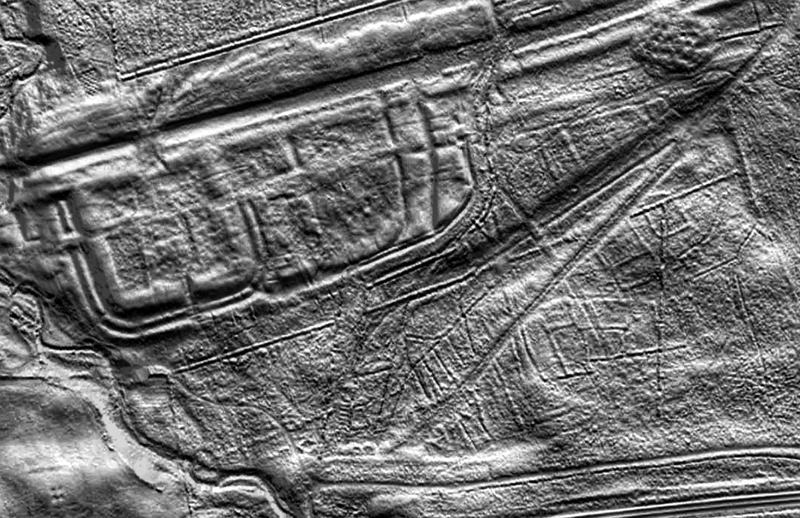
Photo: Dr John Wells / Wikimedia Commons / CC BY 4.0 — Source
LiDAR aerial view of Rough Castle Roman fort on the Antonine Wall, revealing features invisible from ground level. View on Wikimedia Commons · Image: Dr John Wells / CC BY 4.0
Timeline: Rome in the Stirling Area
- c. AD 70–80 — Gask Ridge frontier established: the earliest Roman land frontier system in the world
- c. AD 79–83 — Agricola’s campaigns: forts built at Camelon, Doune and Ardoch; road constructed through the Forth Valley; Drip Ford road built
- c. AD 87–88 — Roman withdrawal from Scotland; Gask Ridge and associated forts abandoned
- c. AD 139–142 — Antonine Wall built: Camelon reoccupied; forts at Mumrills, Rough Castle, Watling Lodge and 14 others garrisoned
- c. AD 154–162 — Antonine Wall abandoned; troops withdraw to Hadrian’s Wall
- AD 208–211 — Severan campaigns: 50,000+ troops; naval supply chain (South Shields → Cramond → Carpow)
- AD 305–390s — Intermittent late Roman campaigns into Scotland (archaeologically invisible)
- 2017 — King’s Park Fort discovered below Stirling Castle
- 2023 — Roman road discovered at the Drip Ford near Stirling
- 2025 — Roman Iron Age burial mounds found at King’s Park
Visiting Roman Sites Near Stirling
Several sites in the area are accessible to visitors:
- Rough Castle (Bonnybridge) — Free access. The lilia pits and fort earthworks are clearly visible. Managed by Historic Environment Scotland
- Watling Lodge (Falkirk) — Free access. Best-preserved section of the Antonine Wall ditch
- Ardoch Roman Fort (Braco) — Free access. Spectacular multi-vallate defences. One of the best-preserved Roman forts in Britain
- Bar Hill Fort (Twechar) — Free access. Bath-house foundations visible on the highest point of the Antonine Wall
- Hunterian Museum (Glasgow) — Houses 18 Antonine Wall distance slabs and the Ardoch tombstone. Free admission
- View Roman sites on the SFAS Interactive Map
Sources and Further Reading
- Scottish Archaeological Research Framework (ScARF), Roman Scotland Panel Report
- ScARF, The Antonine Wall
- Cook, M., “Back and Forth: Roman River Crossings at Stirling,” Taylor & Francis
- Stirling Council, 2000-year-old Roman Road Uncovered Near Stirling (2023)
- Cook, M., The Maeatae (Stirling Archaeology Substack)
- GUARD Archaeology, Excavations at Camelon Roman Fort Annexe
- The Roman Gask Project, theromangaskproject.org
- Historic Environment Scotland, Antonine Wall: Rough Castle
- Canmore, Camelon Roman Fort (46920)
- Canmore, Ardoch Roman Fort (25227)
- Canmore, Doune Roman Fort (24767)
The Stirling Field and Archaeological Society has been exploring Scotland’s heritage since 1878. Join the Society to support our work, or visit our events page to find out about upcoming talks and field visits — including to Roman sites in the area.
Related Event
Ardoch Roman Fort and Muthil Church
10 June 2025