Photo: Paul Sorowka / Own / Society / Used with Permission
A House in the Hills: The Society’s First Dig of the Modern Era
How a dog walk in the Stirlingshire hills led to the discovery of a prehistoric roundhouse — and the Society’s first excavation of the modern era.
When I am out walking the dog or dogs, I am always on the lookout for signs of human habitation. For a number of years I enjoyed the tracks through the forestry beside the King’s Yett Burn, just beyond where the road to Earlsburn enters open moorland. I knew of the Bronze Age cairn — a Scheduled Ancient Monument — near the road, but it was a long time before I realised that a patch of rough ground I often passed had some boulders protruding through the heather. These were soon discovered to be accompanied by large stones concealed beneath it, which together formed a rough circle. I hoped that I had found the remains of an ancient roundhouse.
Later, when we in SFAS were looking for a site to dig, we decided to explore the possible roundhouse. Having obtained the necessary permission from the landowner, we organised a small investigation and — with the help of Stirling Young Archaeologists’ Club — the weekend of 12th–13th July 2008 was spent stripping away the heather and grass.
What the Clearance Revealed
This work, done mostly by the parents, revealed a roughly circular feature formed by a low bank of decayed walling approximately 20cm high, with some protruding boulders — as seen in the photographs below.
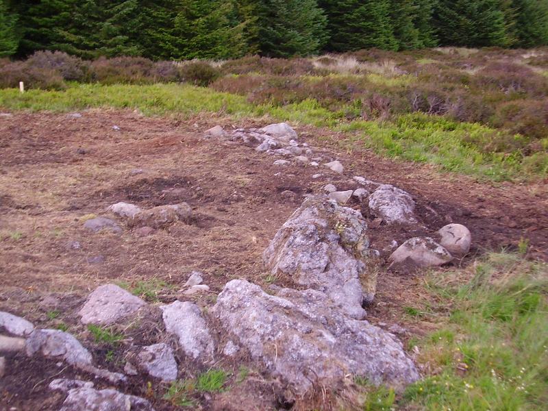
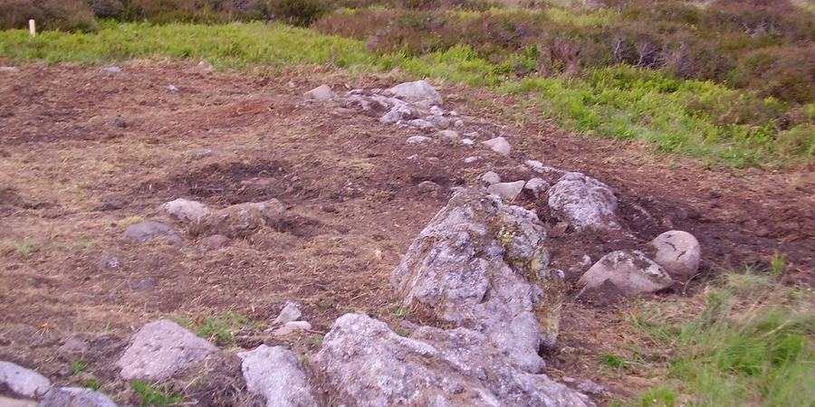
Photo: Paul Sorowka / Own / Society / Used with Permission
Looking along the surviving wall line. The largest facing stones are clearly visible in the foreground, with the wall line continuing into the middle distance. · Photo: Paul Sorowka / SFAS
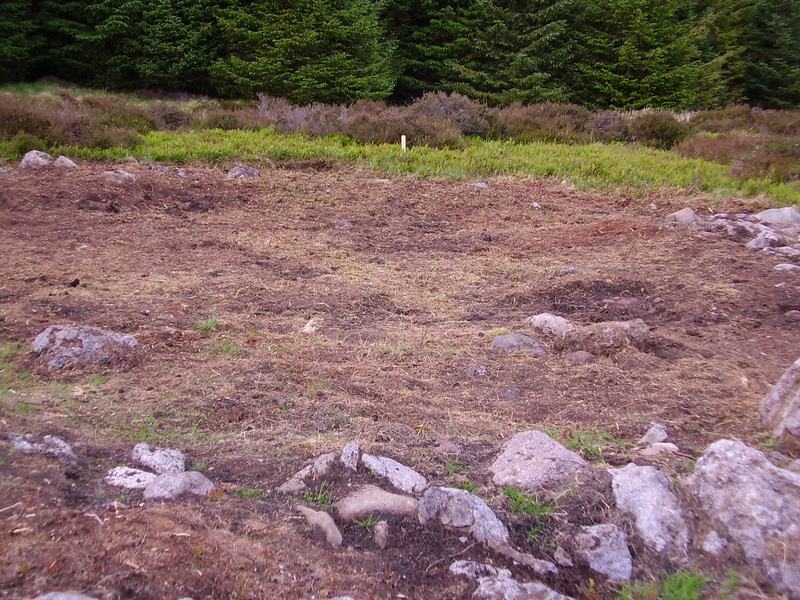
Photo: Paul Sorowka / Own / Society / Used with Permission
Looking across the interior of the roundhouse from the south, showing the cleared floor area. The survey marker post is visible at the rear. · Photo: Paul Sorowka / SFAS
The interior is striking in its spaciousness. This would have been a substantial dwelling — large enough for an extended family group, their domestic equipment, and possibly some animals in a partitioned section during winter months.
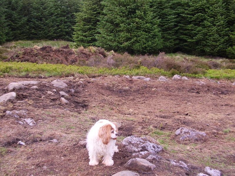
Photo: Paul Sorowka / Own / Society / Used with Permission
View from within the roundhouse looking towards the entrance gap, with the low stone wall arcing to the right. · Photo: Paul Sorowka / SFAS
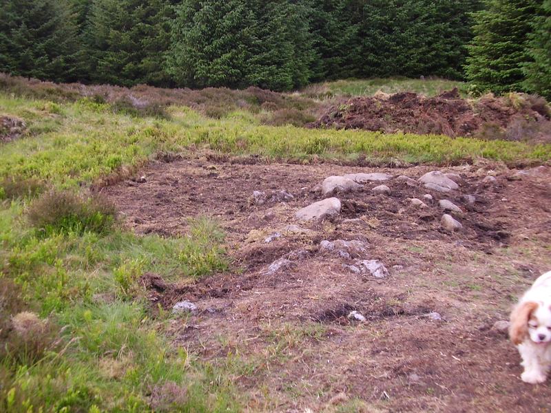
Photo: Paul Sorowka / Own / Society / Used with Permission
Wider landscape view showing the cleared area and the relationship of the structure to the surrounding moorland. The stone wall arc is visible as a low ridge curving around the right-hand side. · Photo: Paul Sorowka / SFAS
Recording the Site
The feature was planned at a scale of 1:20 by groups of youngsters, with guidance from us, using three different methods. First, the perimeter was drawn using offsets measured from a 1 metre string grid. Then the position of boulders within the wall line was drawn by eye. Finally, any large stones enclosed by the perimeter wall were planned using a portable 1m × 1m × 10cm grid. The youngsters quickly learned which method suited their ability and the task they were undertaking.
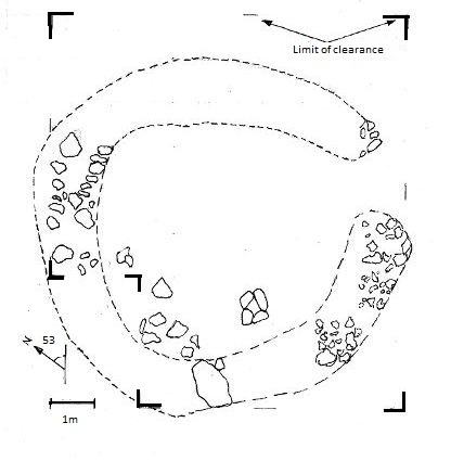
Photo: Paul Sorowka / Own / Society / Used with Permission
The composite plan compiled from the Young Archaeologists’ Club’s separate drawings, at a scale of 1:20. The dashed line indicates the probable original circuit of the wall. · Drawing: SFAS / Stirling Young Archaeologists’ Club
It was not possible with the available resources to strip the entire site, or to draw everything, but the principal dimensions and the location of the entrance were recorded and a composite plan was compiled from the YAC’s separate drawings — which can be compared directly with the photographs.
No finds were made, no stones were moved or removed, and the grass and heather has since re-grown to cover the site and render it almost invisible once more.
The site is located at NS 73126 89580. A more modern, and previously recorded, rectangular stone foundation of a building may be seen not too far away at NS 73254 89482.
What Is a Roundhouse?
For those new to Scottish prehistory, a brief note on the building type. The terms roundhouse and hut circle are often used interchangeably — strictly speaking, archaeologists tend to use hut circle for upland sites where some wall height survives above ground. In either case, circular houses were the dominant form of domestic architecture in Scotland for roughly two thousand years, from the middle Bronze Age through to the early centuries AD. They were built in timber, stone, or combinations of both, depending on what the local landscape provided.
The average roundhouse was between 6 and 10 metres in diameter — roughly the footprint of a modern semi-detached house. Within this space, a family would have cooked, slept, worked, and sheltered through the Scottish winters beneath a conical thatched roof supported on a ring of timber posts.
Dating and Significance
Without excavation, it is not possible to give this particular structure a precise date. Structurally it is consistent with Bronze Age or Iron Age occupation — broadly 2500 BC to AD 100 — a span that covers the period when upland Scotland was more extensively settled than at any time before or since. The presence of the known Bronze Age cairn nearby on the same stretch of moorland adds further weight to the likelihood of prehistoric activity in this immediate area.
The Stirlingshire uplands have a reasonable density of such sites, and this one sits comfortably within a wider pattern of prehistoric settlement along the highland–lowland margin. That it remained unrecorded until a dog-walk drew attention to a few protruding boulders is a reminder of how much of our local heritage still awaits discovery — and how much depends on people who simply keep their eyes open.
Further Reading and Resources
General introductions to Scottish roundhouses:
- Armit, I. (2006) Anatomy of an Iron Age Roundhouse: the Cnip Wheelhouse Excavations, Lewis. Society of Antiquaries of Scotland / Edinburgh University Press.
- Dig It! — ‘What’s a Roundhouse?’
- Current Archaeology — ‘Roundhouses’
The Scottish Archaeological Research Framework (ScARF):
- Iron Age settlement
- Bronze Age settlement and hut circles
- Timber roundhouses in southern and eastern Scotland
Roundhouses near Stirling — published excavations:
- Main, L., et al. (1999) ‘Excavation of a timber round-house and broch at the Fairy Knowe, Buchlyvie, Stirlingshire, 1975–8’, Proceedings of the Society of Antiquaries of Scotland, 128, pp. 293–417.
- Jones, G. (2024) ‘An Early Iron Age Roundhouse at Gartness Road, Drymen, Stirling’, Scottish Archaeological Journal.
- Maclaren, A. (1960) ‘Excavations at Keir Hill, Gargunnock’, Proceedings of the Society of Antiquaries of Scotland, 91 (1957–8).
Finding prehistoric sites in Stirlingshire:
- Canmore — the national record of Scotland’s historic environment, maintained by Historic Environment Scotland.
- Stirling Archaeology Substack — Dr Murray Cook’s current fieldwork news and events.
- SFAS Interactive Archaeological Map — explore sites across the Stirling area.
The Stirling Field and Archaeological Society organises regular fieldwork visits, lectures, and outings across the Stirling area. Non-members are always welcome. For details of upcoming events, see the events page.